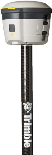
The Trimble R2 gives you the freedom to select the mobile device of your choice including iOS, Android, and Windows devices. Capable of achieving submeter to centimeter level positioning accuracy the Trimble R2 keeps you working productively in a wide range of water and waste-water utility applications, no matter what your workflow requirements are.
Whether you are capturing GIS field assets, locating buried assets such as pipes and valves, or carrying out precision 3D measurements, the versatile Trimble R2 is purpose-built for utility mapping professionals.
Together with Trimble Unity mobile GIS and workflow software, the R2 is simple to setup and easy-to-use. The Trimble R2 pairs with any Trimble handheld, or consumer smart device across a variety of operating systems and platforms to deliver reliable, high quality, real-time data every time.


SPECIFICATIONS
CONFIGURATION OPTION
Type: Bring Your Own Device external GNSS receiver
MEASUREMENTS
Advanced Trimble Maxwell 6 custom GNSS chip
High-precision multiple correlator for L1/L2 pseudo-range measurements
Unfiltered, unsmoothed pseudo-range measurements data for low noise, low multipath error, low-time domain correlation, and high-dynamic response
Very low noise carrier phase measurements with <1 mm precision in a 1 Hz bandwidth
Signal-to-noise ratios reported in dB-Hz
Trimble EVEREST™ multipath signal rejection
Proven Trimble low elevation tracking technology
220-channel GNSS
4-channel SBAS (WAAS/EGNOS/MSAS/GAGAN)
POSITIONING PERFORMANCE4
SBAS (WAAS/EGNOS/MSAS/GAGAN) Positioning1
- Horizontal accuracy: ±0.50 m (1.6 ft)
- Vertical accuracy: ±0.85 m (2.8 ft)
RTX Positioning3
- CenterPoint® RTX
- Horizontal accuracy: 4 cm
- Vertical accuracy: 9 cm
- FieldPoint RTXTM: 10 cm Horizontal
- RangePointTM RTX: 30 cm Horizontal
- ViewPoint RTXTM: 50 cm Horizontal
RTK Positioning2
- Horizontal accuracy: 10 mm + 1 ppm RMS (0.033 ft + 1 ppm RMS)
- Vertical accuracy: 20 mm + 1 ppm RMS (0.065 ft + 1 ppm RMS)
Network RTK2
- Horizontal accuracy: 10 mm + 1 ppm RMS (0.033 ft + 1 ppm RMS)
- Vertical accuracy: 20 mm + 1 ppm RMS (0.065 ft + 1 ppm RMS)
BATTERY AND POWER
Internal: Field replaceable internal battery 7.4 V, 2800 mA-hr, Lithium-ion
External: Power input on the Mini-B USB connector, non-charging as per the USB standard 10 W USB adapter
Power consumption: 4.95 W (VFD 100%), 3.7 W (VFD 12.5%) at 18 V, in rover mode
Operation time on internal battery
- Rover: 5 hours; varies with temperature
MECHANICAL
User interface: LED indicators for receiver status. On/Off key for one-button startup
Dimensions: 14.0 cm (5.5 in) diameter x 11.4 cm (4.5 in) height
Weight: 1.08 kg (2.38 lb) receiver only
ENVIRONMENTAL
Temperature
- Operating: –20 °C to +55 °C (–4 °F to +131 °F)
- Storage: –40 °C to +75 °C (–40 °F to +167 °F)
Humidity: 100% condensing
Waterproof: IP65
Pole drop: Designed to survive a 2 m (6.6 ft) drop onto all faces and corners onto concrete (25C) Shock
- Non-operating: To 75 g, 6 ms, saw-tooth
- Operating: To 40 g, 10 ms, saw-tooth 100 shock events at 2 Hz rate
Vibration: MIL-STD-810G (Operating), Method 514.6, Procedure I, Category 4, Figure 514.6C-1 (Common Carrier, US Highway Truck Vibration Exposure) Total Grms levels applied are 1.95 g
INTERNAL ANTENNA
Frequency Range: L1/L2 (GPS, GLONASS, Galileo, BeiDou, QZSS), MSS (RTX), L1 SBAS
COMMUNICATIONS
USB: 1 USB 2.0 (Type B) device
Wi-Fi: Simultaneous client and access point (AP) modes
Bluetooth wireless technology: Fully-integrated, fully-sealed 2.4 GHz Bluetooth module5
Network protocols: HTTP (web browser GUI); NTP Server, TCP/IP or UDP; NTRIP v1 and v2
Supported data formats
- Correction inputs: CMR, CMR+™, CMRx, RTCM 2.x, RTCM 3
- Correction outputs: None
- Data outputs: NMEA, GSOF
FCC Part 15 (Class B device), CE Mark, RoHS
COMPLIANCE
FCC Part 15 Subpart B (Class B Device) and Subpart C; CAN ICES-3(B)/NMB-3(B), RSS-Gen and RSS-210; R&TTE Directive: EN 301 489-1/-3/-5/-17, EN 300 440, EN 300 328, EN 300 330, EN 60950, EN 50371; ACMA Regulatory Compliance Mark (RCM); CE mark compliance: UN ST/SG/AC.10.11/Rev. 3, Amend. 1 (Lithium-ion Battery, charger not included), UN ST/SG/AC. 10/27/Add. 2 (Lithium-ion Battery, charger not included); C-Tick; WEEE and RoHS compliant.
ACCESSORIES INCLUDED
Power Supply and Power Cord for Dual Battery Charger (North America)
PURCHASED SEPARATELY
2 Meter Carbon Fiber Range Pole
Bipod - Carbon Fiber
Pole Mounts - 7" and 10" Tablets
“Made for iPhone” and “Made for iPad” mean that an electronic accessory has been designed to connect specifically to iPhone or iPad respectively, and has been certified by the developer to meet Apple performance standards. Apple is not responsible for the operation of this device or its compliance with safety and regulatory standards. Please note that the use of this accessory with iPhone or iPad may affect wireless performance.
iPad, iPhone and Retina are trademarks of Apple Inc., registered in the U.S. and other countries. iPad mini is a trademark of Apple Inc.
- Depends on SBAS system performance.
- Accuracy and reliability may be subject to anomalies such as multipath, obstructions, satellite geometry, interference and atmospheric conditions. Always follow recommended practices.
- CenterPoint RTX accuracy is typically achieved within 5 minutes in select regions, and within 30 minutes worldwide. FieldPoint RTX accuracy is typically achieved within 5 minutes in select regions, and within 15 minutes worldwide. RangePoint RTX and ViewPoint RTX accuracy is typically achieved within 5 minutes worldwide.
- Receiver accuracy and convergence time varies based on GNSS constellation health, level of multipath, and proximity to obstructions such as large trees and buildings.
- Bluetooth type approvals are country-specific. For more information, contact your local Trimble office or representative.

